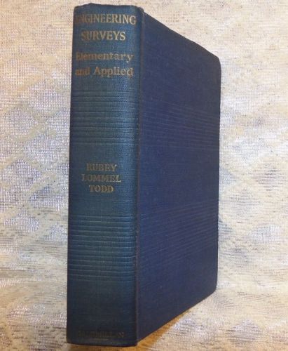
1946 ENGINEERING SURVEYS CIVIL ELEMENTARY & APPLIED INSTRUMENTS METHODS This is an 834 page, 5" x 7 3/4", semi-pliable hardcover book titled Engineering Surveys: Elementary and Applied. The book was written by Harry Ruby, B.S., C.E. Chairman, Department of Civil Engineering, University of Missouri ; George Edward Lommel, B.S., C.E. Professor of Topographical Engineering, Purdue University ; and by Marion Wesley Todd, M.S.C.E. Associate Professor of Topographical Engineering, Purdue University. The book was copyrighted and first published in 1942 by the MacMillan Company.. This is one of the 1946 third printings. As stated in the book’s preface (see image): “This combined volume of Engineering Surveys has been prepared as a text and reference book for the first (Elementary) and the second (Applied or Higher) courses in surveying. The elementary part is identical with “Engineering Surveys: Elementary”, which has passed through several corrected printings and editions, and which continues to be published separately for those preferring a shorter text... The present volume aims to present the entire subject as it is taught throughout the United States, and as specified by the Second National Surveying Teachers’ Conference of the Society for the Promotion of Engineering Education held at Camp Case, Ohio in August 1940: “Elementary Engineering Surveys: History and purposes of surveying; note keeping and theory of errors; distance measurement; leveling; horizontal and vertical angle measurement; methods of traversing; meridian determination; location of details; traverse computations with special emphasis on coordinates; plotting; methods and sources of information of land description, including United States Public Land System, by metes and bounds, and by named subdivision; responsibilities and limitations of land surveyors; adjustment of instruments; and appropriate field practice // “Applied Engineering Surveys: Field practice in adjustments and practical astronomy together with theory dealing with the application of errors and precision; topography and mapping with horizontal and vertical control by transit and stadia, plane table, and the elements of photogrammetry unless the latter is covered in a separate course; hydrographic surveying, including stream gaging where possible; and a general knowledge of other forms of surveying such as underground and mine surveying, use of state plane coordinates, and legal aspects of land surveying.” More than the minimum content of these subjects in included and additional subjects useful to most engineers have been added, such as chapters on city planning surveys and construction surveys. Contents in the form of chapter titles and subtitles are: Engineering Surveys: Elementary Introduction - Engineering Surveys ; Uses of Surveys ; Training Provided by Surveys ; Plane and Geodetic Surveying. Measurement of Distances - Introduction ; Pacing ; Speedometers ; Stadia ; Rules ; Chains ; Tapes ; Horizontal Distances Required in Taping ; Breaking Tape ; Lining and Stationing ; Field Procedure ; Stakes ; Measuring Fractional Tape Lengths ; Slope Taping ; Tape Standardization ; Temperature Correction ; Special Tapes to Avoid Temperature Correction ; Pull or Tension Correction ; Sag Correction ; Normal Tension ; Tape Standards ; Small Errors ; Cumulative Errors ; Compensating Errors ; Mathematical Theory of Probability and Least Squares ; Determination of Probable Error ; Precision Measurements and Computations ; Precision Required in Taping ; Importance of Good Taping ; Measurement of Angles with Tape. Field Notes - Functions of Field Notes ; Technique of Note Keeping ; Types of Notes ; Index ; Lettering and Symbols ; Notekeeper. Compass Surveying - Types of Compasses ; Magnetic Declination ; Variation of Declination ; Setting Off the Declination ; Precision of the Needle ; Dip of the Needle ; Bearings of Lines ; Obtaining a Compass Bearing ; Calculation of Angles from Bearings and Vice Versa ; Local Attraction ; Common Errors ; Precision of Readings ; Uses of Compass. Leveling - Level Surface and Level Datums ; Assumed Level Datum ; Available Elevation Data ; Determination of Approximate Differences in Elevation ; Spirit Level ; Line of Sight ; Engineers’ Level ; Optical Properties ; Optical Systems ; Parallax ; Dumpy Level ; Wye Level ; Other Types ; Hand Level and Clinometer ; Leveling Rods ; Targets ; Setting Up the Level ; Bench Marks and Turning Points ; Differential Leveling ; Tape rod ; Signals ; Closing Level Circuits ; Common Mistakes ; Small Errors ; Profile Leveling ; Refraction ; Curvature ; Lengths of Sight ; Probable Error in Setting Level Target ; Reciprocal Leveling with One Level ; Reciprocal Leveling with Two Instruments ; Customary Limits of Error ; Adjustment of Level Circuits ; Leveling with Barometer. The Transit - General Uses ; Transit Circle Graduations and Verniers ; Setting Up the Transit ; Measuring Horizontal Angles ; Measuring Horizontal Angles by Repetition ; Laying Off an Angle by Repetition ; Direct Angles or Angles to the Right ; Deflection Angles ; Azimuth Angles ; Traversing by Azimuth ; Comparison of Methods of Designating and Measuring Angles with Transit ; Sight Points ; Signals ; Prolonging a Straight Line ; Passing Obstacles ; Measuring Vertical Angles ; Checking Angles by Magnetic Needle ; Establishing Points in a Vertical Plane ; Intersecting Lines ; Locating Buildings and Improvements from a Transit Line ; Angular and Distance Errors. Adjustment and Care of Instruments - Selection and Purchase of Instruments ; Care and Use of Instruments ; General Importance of Adjustments ; Field and Shop Adjustments ; Focusing the Eyepiece of Any Transit or Level ; Understanding of Adjustments ; Field Transit Adjustments ; Shop Transit Adjustments ; Field Adjustments of the Dumpy Level ; Field Adjustments of the Wye (Y) Level ; Field Adjustments of the Compass ; Field Adjustments of the Hand Level and of the Clinometer ; General Procedure. Observations for Meridian - The Scope of this Chapter ; Determining a Meridian by Observation on Polaris at Elongation ; Computation for the Observation at Elongation ; Field Work for a Polaris Observation at Elongation ; Determining a Meridian by Direct Observation on the Sun ; Field Work for a Direct Solar Observation ; Other Field Methods of Direct Solar Observation ; Computations for a Direct Solar Observation. Stadia Surveying - The Stadia Theory ; Inclined Sight Formulas ; Reduction of Field Notes ; Approximate Formulas ; Beaman Stadia Arc ; Stadia Multiplying Constant ; Field Procedure ; Vertical Angles to any Point on the Rod ; Stadia Rods ; Advantages of Stadia ; Common Mistakes ; Precision of Stadia Distances ; Precision in Stadia Elevations. Topography - Definition ; Hachures ; Contours ; Use of Topographic Maps ; Maps Available ; Specific Information from Contour Maps. Triangulation - Definition ; Minor Triangulation ; Triangulation Systems ; Shape of Triangles ; Computations ; Measurement of Base Lines and Angles ; Elevation by Triangulation ; Construction Triangulation ; City Triangulation ; Hydrographic Surveys ; Precise Triangulation ; Azimuth Mark Set for Use in Local Land Survey ; Conclusions. Land Surveys - General - Introduction ; Records ; Record Searchers ; Courts ; General Considerations Governing Land Surveys ; Marking Corners ; Difficulties of Land Resurveys ; Weight Accorded Various Factors in Surveys ; Procedure in Resurveys ; Subdivisions ; Metes and Bounds Surveys ; Law of Land Surveying / Original Federal Surveys - United States Public Land Surveys ; Lands So Surveyed ; Historical and Legal ; Initial Points, Meridians, Base Lines, Guide Meridians, and Standard Parallels ; Township Exteriors ; Subdivision of Township into Sections ; Irregular Boundaries ; Order of Surveys ; Subdivision of Sections ; Meandering ; Permissible Limits of Errors and Closure in United States Public Land Surveys ; Marking Corners and Lines and Noting Resources / Irregularities in Surveys / Irregularities Due to Changing Instructions - Convergency of Meridians ; Special Surveys and Instructions / Original State Surveys - State Systems of Plane Coordinates / Private Resurveys - Identification of Existent Corners ; Restoration of Lost Corners ; Eight-Sided Section. Route Surveys - The Reconnaissance ; Traversing ; Compass Traversing ; Traversing ; Aerial Surveys ; The Preliminary Survey ; The Final Location ; Construction Stakes ; Horizontal Curves ; Vertical Parabolic Curves ; Grading ; Slope Stakes ; Computation of Grading ; Borrow Pits. Area Surveys - Maps Available ; Control ; Traverse ; Filling in Details ; Transit-Stadia / Following Control Surveys / Carrying Control Simultaneously - The Plane Table ; Rectangular Control ; Timber Land Surveys ; Precise Topography on Small Areas ; Photographic and Area Mapping ; Scale and Use of Maps ; Plotting the Data ; Mapping by Contract. City Surveys - The City Engineer and the Private Engineer ; Lot Surveys and Subdivision Plots ; Surveys by the City Engineer ; Precision of City Surveys ; Staking Out Structures. Office Work - General Information ; Errors and Omissions ; Organization of the Office ; Office Records ; Tables and Diagrams ; Reproduction of Maps and Plans ; Suggestions to Computers ; Office Equipment ; Map Papers ; Placing the Drawing on Paper ; Coordinate Axes ; Other Plotting Methods ; Finishing the Map. Computation of Traverses, Latitudes and Departures, Coordinates and Areas - Checking Angles of a Traverse ; Latitudes and Departures ; Adjustment of Traverses ; Coordinates ; Area by Coordinates ; Comparison of Methods of Computing Areas ; Checking and Plotting by Coordinates ; Missing Measurements ; Off-Line Traverses ; Coordinates Available. Organization of Surveys - Planning the Survey ; Simple Surveys ; Extensive Surveys ; Organization ; Factors Affecting Cost ; Transit-Tape Traversing ; Transit-Stadia Traversing ; Sketching Board Traversing ; Levels ; Area Surveys ; Filling in Details ; Filling in Details by Rectangles ; Triangulation Surveys ; Examples of Cost. Engineering Surveys: Applied Introduction to Applied Engineering Surveys - General ; Instruments ; Organization of the Survey ; Surveys by Contract. Horizontal Control - Triangulation - Fundamentals ; Systems ; Classification and Uses ; Reconnaissance ; Strength of Figure ; Establishment of Stations ; Signals and Towers ; Curvature and Refraction ; Angle Measurement in Triangulation ; Adjustment of Angles ; Quadrilateral Adjustments ; Spherical Excess ; Calculation of Sides ; Base Line Measurement ; Correction for Slope ; Correction for Temperature ; Correction for Temperature or Pull ; Correction for Sag ; Reduction to Datum ; General Statement on Corrections / Traverse - Fundamentals ; Principal Use ; Precision ; Establishment ; Traverse Taping ; Traverse Angles ; Signals ; Traverse Adjustment ; General Statements. Engineering Astronomy - Relative Accuracy / General Theory - Celestial Bodies ; The Celestial Sphere ; Earth’s Motions ; Great and Small Circles ; Azimuth and Altitude – The Horizon System ; Right Ascension and Declination – The Equatorial System ; Hour Angle and Declination – The Hour Angle System ; The Astronomical Triangle ; Terrestrial and Celestial Latitude ; Special Conditions of Observation ; Time Measurement ; Sidereal Time ; Solar Time ; Conversion of Time Intervals ; Longitude and Time ; Sidereal Time and Right Ascension ; Corrections to Observed Altitudes / Instrument Equipment - Transits ; Solar Attachment ; The Sextant ; Adjustments of the Sextant ; Spherical Trigonometry ; True North ; Polaris at Elongation ; Polaris at Any Hour Angle ; Latitude and Longitude from a Map ; Equal Altitude Observation on Any Star ; Azimuth from Solar Observations ; Latitude and Longitude Known / Latitude Observations - Observations at Culmination ; Latitude on an Established Meridian ; Time of Culmination ; Latitude from Polaris at Any Hour Angle ; Latitude from the Sun at Any Hour Angle / Longitude and Time - Principles of Observations ; Time at Local Apparent Noon ; Time from a Star Observation ; Observations from Longitude ; Precision. Vertical Control - General Statement ; Establishment of Control ; Bench Marks ; Specifications ; Equipment ; Field Procedure ; Computation and Adjustment. Topographic Details - Field Methods - Stadia Measurements / The Transit Method - Equipment ; Control ; Transit Survey Details ; The Stadia Circle ; Plotting Stadia Notes / The Plane Table Method - The Plane Table ; Beaman’s Arc ; Plane Table Adjustments ; Locating Points by Radiation ; Locating Points by Intersection ; Resection ; The Three Point Problem ; Plane Table Traverse and Triangulation ; Plane Table Operators / Office Practice - Map Making ; Scales ; Materials ; Plotting ; Title ; Lettering ; North Point ; Symbols ; Legend ; Color. Photogrammetry - History / Aerial Camera - Classification ; Focal Length ; Principal Point ; Fiducial Marks ; Focal Plane Flatness ; Shutter ; Filters ; Film ; Controls ; Lens / Photographic Airplanes - Planes / Flying - Importance ; Flight Map ; Overlap / The Photograph - Scale of the Photograph ; Time Interval of Exposure ; Number of Pictures to Cover a Given Area ; Displacement ; Displacement Due to Topographic Relief ; Parallactic Displacement ; Tilt / The Stereoscope - The Stereoscope ; Stereoscopic Vision ; Fundamental Principles ; The Stereocomparator ; Stereoscopic Fusion / Classification of Maps - Classification ; Mosaics ; Maps / Control Surveys - General ; Horizontal Control ; Vertical Control ; Picture Control ; Plotting Control ; Preparation of Photographs ; Radial Line Method ; The Template Method ; Slotted Template Method ; Detailing Maps ; Contouring ; Stereocomparagraph Theory ; Methods of Securing Contact Prints or Enlargements ; Uses, Control, and Contracts for Aerial Surveys. Map Projections and State Coordinates - General Statements ; Projections ; Classification of Projections ; The Mercator Projection ; The Lambert Conformal Conic Projection ; Other Projections ; State Plane Coordinates ; Plane Coordinate Tables ; Military Grid System. Hydrographic Surveying and Flow Measurements - Hydrographic Surveying - Definition ; Purposes of Hydrographic Surveying ; Equipment ; Hydrographic Charts ; Control ; Filling in Detail ; Yardage on Dredging Projects ; The Volume of Impounded Water ; The Fluctuation of Tides ; Measurements of Tidal Currents ; Drainage Basin Areas / Flow Measurements - Discharge Measurements ; The Price Current Meter ; Variations in Velocity ; Use of the Price Current Meter ; Stage Readings ; Effect of Changing Stage on Stream Discharge ; Manipulation of Current Meter ; Floats for Velocity Determinations ; Use of Open Channel Formulas for Determining Average Velocity ; Determination of Cross-Section at a Station ; se of weir Flumes and Discharge Measurements. Legal Principles of Boundary Surveying - General ; Review ; Additional legal Principles of Boundaries ; Subdivisions ; Maps, Plats, and Field Notes ; Land Descriptions ; Compete Description by Means of a Plat Only ; General Remarks ; The Surveyor’s Legal Rights and Responsibilities in Boundary Disputes ; State Systems of Plane Coordinates ; Retracing the United States Public Land Surveys ; Historical Incident. City Planning Survey - Introduction ; Planning Agencies ; The Civic Survey ; City Maps ; The Survey ; Topographic Details ; Planning Surveys and Maps ; Traffic Surveys ; The Traffic Census ; Intersection Studies ; Zoning Surveys ; Land Subdivision ; Subdivision Standards ; Platting Guides ; Subdivision Design. Underground Surveys - Introduction ; Definitions ; Differences from Surface Surveying ; Transits and Levels ; Special Requirements in Transit Adjustments ; Using the Transit ; Using the Side Telescope ; Other Equipment ; Illuminating Instruments and Points ; Traversing ; Curves ; Marking Stations ; Notes and Calculations ; Field and Office Forms ; Maps ; Sections ; Mine Models ; Stope and Tunnel Surveys ; Tunnel Portals / Transferring a Meridian Underground - Tunnels ; Inclined Openings ; Plumbing Vertical Shafts ; One-Shaft Methods ; Two-Shaft Method / Other Underground Surveys - Transferring Elevations Down a Shaft ; Bore-hole Surveying ; Underground Connections ; Geophysical Exploration ; Location of Underground Utilities ; Mineral Land Surveys. Construction Surveys - General ; Other Engineering Associated with Construction Surveys ; Necessary Staking ; Checking all Previous Surveys ; Avoidance of Disturbance ; Elevations / Surveys for Various Types of Construction - Route Surveys ; Tunnels ; Sewers and Pipe Lines ; Anchor Bolts ; Bridge Sites ; Buildings ; Groups of Buildings and Industrial Plants ; Reservoirs and Dams ; Quantity Surveys and Bidding. Tables - Common Logarithms of Numbers from 1 to 10,000 to Five Decimal Places / Conversion Factors / Actual Values of Trigonometric Functions. Functions from 0 degrees to 90 degrees at Intervals of One Minute to Five Decimal Places / Correction in Feet from 100 Feet of Slope Taping to the Horizontal / Stadia Coefficients, Vertical Rod / Convergency of Meridians, Six Miles Long and Six Miles Apart, and Differences of Latitude and Longitude / Average Air Temperature Corrections for Barometric Leveling / Inches in Decimals of a Foot / Trigonometric Formulas for the Solution of Plane Triangles / Practice Notes / Seven-place Natural Sines and Cosines. Condition - The book includes numerous tables, charts, diagrams and illustrations including some vintage photographic picture illustrations of equipment and instruments. The book is clean and complete. The cover binding is square and both cover and pages are tightly bound. The gold spine edge print on the medium blue cover cloth somewhat faded. There are mild stress lines on the inside of the front cover indicating slight bending of the semi-pliable cover but the cover board is still strong in this area and the only indication on the outside of the front cover is a slight ripple in the cover cloth near the middle of the bottom edge and extending upward about one inch. Cover cloth wear is otherwise very slight including the edges and corners. There is a previous owners name with city and state abbreviation written neatly in ink on the inside of the front cover. There are no other markings in the book. The pages are crisp. One page has a small marginal edge tear. There are no other torn pages. There are no missing, loose, creased or marked pages. The book appears to have been little used, well cared for and is in very good condition. Buyer pays S&H. Payment must be via paypal. Books will be shipped in hardboard packages. When available, shipping may be via media mail. Wherever possible, multiple auction purchases ending the same day, will be combined in a single package with the total shipping cost reduced and adjusted for the combined weight. Click here to see my other auctions
By clicking "Accept All Cookies", you agree to the storing of cookies on your device to enhance site navigation, analyze site usage, and assist in our marketing efforts.